our maps

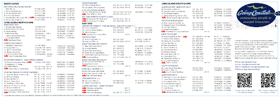
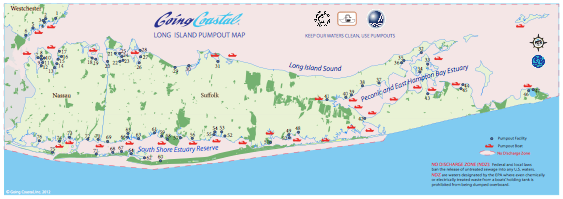
Pumpout stations, pumpout boats and No Discharge Zones located in the waters surrounding Long Island, NY. The waters surrounding Long Island support a variety of possible uses—fish and shellfisheries, fish spawning areas, breeding grounds, valuable wildlife habitats, bathing beaches, commercial and recreational boating, and a profusion of recreational resources. All of the Long Island Sound, South Shore Estuary and the Peconic Bay are No Discharge Zones where the discharge of any sanitary waste product from a vessel is prohibited.
Violation of the NDZ (NYS Navigation Law §33.e) may result in fines up to $500 for a first offense and $1000 for subsequent violations. The recreational vessel population, 11,693, was estimated using 2008 recreational vessel registrations. In addition to recreational vessels, the Sound is used by commercial vessels.
Long Island Pumpout Maps are available at Long Island marinas.
This project was created by Going Coastal, Inc. with funding from a Clean Vessel Act grant provided by the New York State Environmental Facilities Corporation and a software grant from ESRI.

Long Island Pumpout Map
Pumpout Maps go mobile
Maps are available at Long Island marinas and boatyards. Mobile phone map of Long Island pumpouts available here.


SCAN for Mobile Map